City Profile
Vision
A God-Centered City, Learning Center, Vibrant Business Hub, Premier Eco-tourism Destination in Northwestern MIndanao with empowered stakeholders living in a peaceful, progressive and happy environment spearheaded by committed and competent servant leaders.
Mission
To integrate and ensure the delivery of quality basic services and promote eco-tourism investment through good governance in order to uplift the living standard of the people.
CITY SETTING
Tangub City is located at the southern curve of the D-shaped province of Misamis Occidental. It is embraced by the placid water of Panguil Bay in the South, sheltered from the onslaught of typhoon by the mighty Mt. Malindang Range in the North, bordered by Ozamiz City in the East and the Municipality of Bonifacio in the West.
The topography of the city is approximately 40% plain along the coast of Panguil Bay and 60% rolling and hilly, gradually rising to the Mt. Malindang Range Natural Park. The panoramic and aerial view of the City remained vivid and unblocked notwithstanding the immense infrastructure developments in the lowlands. Motorists and travelers are still at liberty from weariness normally caused by traffic congestion. This may be attributed to the readily widened and paved roads even in the remote places of the city.
TANGUB CITY FACTS
CITY: Tangub City
PROVINCE: Misamis Occidental
REGION: X
INCOME CLASS: 4th Class Component City
LAND AREA: 17,211.8952 hectares
BARANGAYS: 55 - 32 Rural& 23 Urban (15 coastal barangays)
SETTING ADVANTAGE
Tangub City is the entry point of Misamis Occidental from the Regional Capital Cagayan de Oro City and the neighbouring industrialized cities. It takes 20-30 minutes to Ozamiz City and about 4 hours and 31 minutes to Cagayan de Oro City with a distance of 20 km. and 170 km., respectively.
With the completion of the Panguil Bay Bridge, transport of goods and commuters to Tubod through Roll-On, Roll-Off (RORO) from Ozamiz Port to Mukas of about 1.5 to 2.5 hours including loading and unloading time will be reduced down to 7 minutes through the bridge.
NATIONAL SETTING
The Philippine archipelago is of volcanic origin transformed by the time into mountains and plains, valleys and volcanoes, bays, lakes, rivers and waterfalls. The country is now a tourist destination endowed with pristine beaches occupying 18,000 kilometres of coastlines.
Being as such, it is studied with seas and oceans having three major islands namely Luzon, Visayas, and Mindanao grouped into 17 regions, 81 provinces, 144 cities, 1,490 municipalities, and 42,036 barangays.
REGIONAL SETTING
REGION: REGION X Northern Mindanao
PROVINCES: 5
CITIES: 9
MUNICIPALITIES: 84
BARANGAYS: 2,020
AREA: 19,279.60 sq. km.
POPULATION: 4.6 million (2015)
LANGUAGE: Bisaya, Boholano, Cebuano (major)
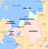
PROVINCIAL SETTING
MISAMIS OCCIDENTAL is a province located in the region of Northwestern Mindanao in the Philippines. Its capital is the City of Oroquieta. The province borders Zamboanga del Norte and Zamboanga del Sur to the west and is separated from Lanao del Norte by Panguil Bay to the south and Iligan Bay to the east.
Office Hours
Monday - Friday
8:00 am - 5:00 pm
(except holidays)
Email: cgo.tangubcity@gmail.com
Address
Barangay 1, Tangub City
Misamis Occidental 7214
Philippines
Follow Us

